Let’s start with environmental context when learning about our White Salmon history
and historic places. This research and documentation was created as part of the
City of White Salmon’s 2040 Comprehensive Plan.
The city of White Salmon lies in a transition zone between the maritime climate
west of the Cascade Mountain Range and the dry continental climate of the
intermountain region to the east. This transition zone is characterized by mild, dry
summers and cool, wet winters. White Salmon is sometimes called the “Land
where the sun meets the rain.”
Successive floods, the Bretz or Lake Missoula floods of the late Pleistocene and
early Holocene Epoch, scoured the land in some areas and deposited sediment
elsewhere. The central city of White Salmon is situated on a bluff approximately
550 feet above the Columbia River. The city also includes approximately three-quarters
of a mile of river frontage, including two established fishing sites under
tribal jurisdiction. The area’s geologic history and climate greatly influenced
White Salmon’s pre-contact and post-contact culture and history.
Inhabitants
Humans have inhabited the Mid-Columbia Plateau and Columbia River basin for at
least 12,000 years. The earliest peoples developed diverse cultural patterns and
several subdialects of the Sahaptin and Chinookan language groups. A common
bond among Mid-Columbia inhabitants was the Columbia River, an artery of
commerce and cultural exchange and its natural resources. The abundance of
salmon was central to the life cycles of early inhabitants.
Over time, the population of the Mid-Columbia region shifted from a huntergather
subsistence pattern to more settled villages beginning around 4,000 years
ago. One of the oldest known settlement sites in the area, south of Klickitat County
in Oregon, dates to 9,785 years ago.
The four tribes with treaty rights within the area include the Yakama Nation, Warm
Springs, Umatilla, and Nez Perce. Locally, tribal people fished for salmon in the
rivers, hunted game in the upland forests and meadows, and harvested food and
medicine in the prairies. Within the Mid-Columbia region, lithic sites, rock cairns,
huckleberry trenches, quarries, camps and villages, and pictographs and
petroglyphs are physical evidence of the long relationship of the native
people to the land.
Prior to contact with Euro-Americans, the upper Chinookan people resided in oval
or circular pit houses. Constructed with a roof of poles, brush, or mats and partially
sunk into the earth, some circular pit houses could be up to 50 feet in diameter
and 12 feet in depth. In Klickitat County, a good example of a pit house village is
the Rattlesnake Creek Site located on Department of Natural Resources lands
north of Husum. More than 2,000 archaeological sites have been recorded in
Klickitat County.
The earliest written evidence of contact between Euro-Americans and the
indigenous population in the White Salmon area, the journals of Lewis and Clark,
indicate a village near the river that Lewis and Clark named the White Salmon
River. The Corps of Discovery members observed multiple subterranean structures
with conical roofs as they traded with the native population who spoke an Upper
Chinookan dialect.
White Salmon History: Early Settlers
After the Lewis and Clark Expedition’s brief 1805 and 1806 visit to the White
Salmon River, direct Euro-American presence in the area was limited. In 1843, the
first wagon caravan of 900 emigrants reached The Dalles in the Oregon Territory;
however, most early Euro-American settlers journeyed to the fertile Willamette
Valley. In 1853, Erastus and Mary Joslyn, traveling downriver by steamboat,
disembarked at The Dalles. Later, they continued downriver and spotted fertile flat
land on the north bank of the Columbia River in the Washington Territory,
approximately one mile east of the White Salmon River, and purchased their
homesite from the Klickitat Tribe. After the Klickitat Tribe moved onto the Yakama
Reservation in 1855, Euro-American settlement accelerated. In 1867, Mary’s
brother James Warner arrived and established a post office. In 1874, A. H. and
Jennie Jewett arrived and settled on the bluff , today’s White Salmon. The Suksdorf
family arrived the same year and settled on the flatland along the Columbia River,
now Bingen.
Early Development
Agriculture and natural resource extraction drove the early local economy. Early
inhabitants of White Salmon and the surrounding area raised cattle for the eastern
mines and harvested timber to fuel the steamboats. (HRA 1995 and McCoy 1987).
Wheat farming and salmon harvesting also built the local economy. The Jewett
family are often credited with being the catalyst of the renowned White Salmon
Valley horticulture industry. The Jewett’s nursery and resort became a nationally
known showplace for visitors. The Jewett family was instrumental in development
of the City’s water system, and they made donations of land for Bethel Church.
A ferry provided transport service between the White Salmon settlements, and
Hood River, Oregon. The community constructed the Dock Grade Road to the
Palmer Ferry Landing west of the present-day approach to the White Salmon-
Hood River Bridge. Horse-drawn wagons transported cargo and passengers to a
flight of stairs that led up the embankment to the town of White Salmon.
In the early twentieth century horticulture, particularly raising fruits and berries,
was an important economic driver in the area. A combination of horticulture,
railroads and roads, and land speculation led to the “Apple Boom” of the 1910s.
(Patee 2016) As prosperity increased, so did discord among the upland and
lowland families resulting in the construction of what today is known as Dock
Grade Road. The questions of the day included where the roads, railroad, post
office, and water source should be built – close to the river or on the upland.
Theodore Suksdorf platted Bingen in the lowlands in 1892. Bingen opened its
post office in 1896. Mr. Jewett platted White Salmon and the town became
incorporated in 1907.
20th Century Trends
The Spokane, Portland, and Seattle railroad came through the Columbia River
Gorge in 1908 with a stop at Bingen. Was the station to be named after Bingen or
White Salmon? The compromise was to name the ”Bingen-White Salmon“ railroad
station after both towns. Thereafter, the two cities, Bingen and White Salmon,
grew side by side but at different elevations. That same year electric lights came to
White Salmon, along with the first fire hydrant, and in 1910 the first sidewalks were
built. The Condit Dam on the White Salmon River was completed in 1913 and
provided electricity to the area and as far away as Camas, Washington.

The Klickitat County government began planning the current road connecting
Bingen and White Salmon, now Washington State Route 141 (SR14), in the 1910s
and local volunteers, under County supervision, began construction of the road in
the 1920s. The Hood River Bridge over the Columbia River opened in 1924. SR
141 provided a vital link between the Columbia River and interior locations of
Trout Lake and Glendwood. SR 141 became to be known as White Salmon’s Main
Street. SR 141 Alternative now bypasses downtown White Salmon and serves as a
principal corridor to the inland recreation areas near Husum, Trout Lake, Mt Adams
wilderness and recreation areas, and the Bird Creek Meadows on the Yakama
Reservation. The economic history of White Salmon has been driven by canoes,
trails, ferries, steamboats, trains, and roads.
In the 1970s White Salmon civic leaders, perhaps because the Suksdorf family had
named the settlement Bingen after their ancestral home of Bingen am Rhein15,
were attracted by a minor national trend of revitalizing a community by adopting
an architectural theme. The faux Bavarian theme seemed to work well in
mountainous Leavenworth, WA so why not in White Salmon, too? While
Leavenworth succeeded in drawing tourist to its theme park-like town, White
Salmon did not fare as well. Only a few buildings retain any faux Bavarian design
Congress passed the Columbia River Gorge National Scenic Area Act (Act) and
President Ronald Reagan signed the Act on November 17, 1986. The Act mandates
the protection and enhancement of scenic, cultural, natural and recreation
resources and the protection and support of the Gorge economy16. The Act
designated a total of 292,500 acres for special protection on both sides of the
Columbia River from the outskirts of Portland-Vancouver in the west to the semiarid
regions of Wasco and Klickitat counties in the east. The Act created 13 urban
exempts areas including the White Salmon/Bingen Urban Exempt Area. Most
residential and commercial development within the Columbia River Gorge
National Scenic Area is encouraged to take place within one of the 13 designated
Urban Exempt Areas.
White Salmon, since the late 1990s, has become a destination for recreationists
and tourists. The community offers all city services and provides retail, medical,
cultural, educational, and recreational facilities. The community of White Salmon
has grown from its birth in 1907 and has established itself as a vital part of the
Columbia River Gorge.
Local Resources of White Salmon History
Historic and Cultural Sites and Structures
Community members are proud of White Salmon’s cultural heritage and history.
To preserve and share that heritage, citizens of White Salmon and West Klickitat
County established the West Klickitat County Historical Society in 1984. The
Society’s collection of data, artifacts, and pictorials are housed in the Gorge
Heritage Museum, formerly the Bingen Congregational Church (circa 1912).
The West Klickitat Historic Society and knowledgeable community members
consider many late nineteenth and early twentieth-century buildings to be of
local historical significance. The White Salmon 2012 Comprehensive Plan
identified several notable locally significant buildings.
Evolving Inventory of Historic and Cultural Resources
Local Historic Resource Strategies
Many communities have adopted historic preservation programs which include:
• a methodology for conducting a local survey of historic or cultural resources;
• criteria for establishing local historic or cultural significance;
• creating a City-administered preservation commission or committee; and
• adoption of an historic preservation ordinance.
White Salmon could employ such proactive strategies. Until such time, however,
identification of historic resources in White Salmon will be based on guidance
and programs developed by state or national agencies, or what someone locally
thinks is old and of historic intertest. Creating a more robust historic and
cultural resource preservation program requires a commitment from the
local government, dedicated local supporters, and the guidance of
qualified professionals.
The Washington State Department of Archeology and Historic Preservation
(DAHP) is the primary state agency supporting historic preservation and
cultural resource programming. DAHP is an excellent resource for
professional guidance on:
• Historic building survey and inventory;
• Archaeology survey and inventory;
• Model historic preservation ordinances;
• Historic research and building review;
• Historic Preservation law;
• Certified Local Government (CLG) program; and the
• Main Street program.
Evolving Historic Resources
History evolves and what was once new or familiar may gather historic or cultural
significance over time. Consequently, the inventory of historic resources changes
and expands through the years. Best inventory practices are for a community to
reevaluate the local inventory each time the community updates its
comprehensive plan.
The George and Louisa Aggers House, 464 SW Eyrie Road, known as “Overlook,” is
in the Urban Exempt Area. In 2020, the property was listed in the Washington
State Historic Register17. Overlook was once part of a small 46-acre cherry orchard
business on the western edge of White Salmon. The 1910 craftsman style
farmhouse serves as an excellent example of Arts & Crafts dwellings from the early
twentieth century.
White Salmon is also home to a notable collection of early to mid-twentieth
century commercial and institutional buildings, several of which were designed
and constructed by Day Walter Hilborn, one of the most prolific and important
architects in the history of southwest Washington State19. Hilborn is credited with
at least seven commissions in White Salmon, including the White Salmon Post
Office (1941), B.O.E. Elks # 163, Bethel Congregational Church (1947), a movie
theater, rodeo grandstand, and several private residences.
The Washington State Department of Archaeology and Historic Preservation
(DAHP) maintains an inventory of historic and cultural resources. Some of the
properties are eligible for listing in the National Register of Historic Places (NRHP).
See Appendix A, White Salmon Area Inventory of Historic Resources, DAHP –
Select. Currently, there are no properties in White Salmon listed in the NRHP;
however, investigation by DAHP representatives has determined that several
historic resources may be eligible for listing in the NRHP.
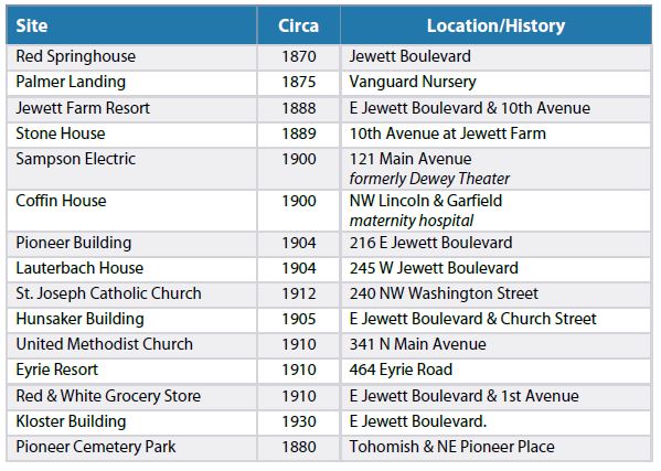
The importance of periodic updates to the historic inventory is illustrated in
Table below. A decade ago, the community might not have considered the cluster of
residential dwellings to have architectural significance. However, in 2020 a team of
qualified historic and architectural professionals prepared Historic Property
Report(s) for these residences and concluded that the cluster of houses may be
eligible for listing in the National Register of Historic Places because of the local
architectural character.

Click Here to Print this Document: White Salmon History and Historic Places